I will interpret drone images to generate digital data

T
timakrida
T
timakrida
Krida

Level 1

About this gig

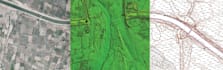
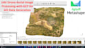
IMAGE PROCESSING SERVICE

From aerial images taken according to photogrammetry standards, Drones Imaging provides you expertise in carrying out topographic surveys and editing topographic maps. We thus provide you with all the geospatial data useful to the construction, public works, earthmoving and mining industries.

Depending to Drone survey data, the following services will be provided:

Drone Data processing with or without Ground Control Points.


We build your geographical data

  • Orthomosaic (GeoTIFF, KMZ, ECW and other formats).
  • Dense cloud (DWG, DXF, E57, LAS and other formats).
  • Dense cloud filtered by class (DWG, DXF, LAS and other formats).
  • Digital Surface Model (GeoTIFF and other formats).
  • Digital Terrain Model (GeoTIFF and other formats).
  • Digital Slope Model (GEOTIFF and other formats).
  • Textured 3D model (Obj and other formats).

Contact me before creating Order

Get to know Krida

Krida

I will create professional GIS maps, bathymetric analysis

5.0(75)

Level 1

  • FromMorocco
  • Member sinceSep 2020
  • Avg. response time1 hour
  • Last delivery1 week
  • Languages

    English
Are you looking for a professional GIS analyst, cartographer, and geologist with over 10 years of experience? You’ve found the right expert! I specialize in GIS mapping, spatial analysis, hydrology, and remote sensing using ArcGIS, ENVI 5.3, QGIS, and advanced geospatial tools. I have successfully delivered projects in environmental studies, geology, topography, hydrology, stormwater management, and urban planning. My Services Include: Cartography & Symbology –Bathymetric Data Analysis-Hydrology & Stormwater Manaent – runoff modeling, watershed delineation, drainage maps. Topographic Mapping