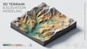
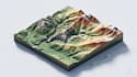
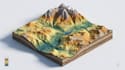
I will create 3d terrain maps, topographic maps, contour maps and landscape model

V
victoriabran4
V
victoriabran4
Victoria

About this gig

Turn terrain data, site references, and landscape concepts into detailed 3D terrain maps that make elevation, landforms, and topography easier to understand.


I create 3D terrain maps, topographic maps, contour maps, and 3D landscape models for presentations, visualization, planning, research, and digital projects.


What I Can Create

  • 3D Terrain Maps
  • 3D Topographic Maps
  • Contour & Elevation Maps
  • Mountain Terrain Models
  • 3D Landform Visualizations
  • Low Poly Terrain Models
  • 3D Relief Maps
  • Hills, Ridges & Valley Models
  • Natural Landscape Models
  • Custom Terrain Visualizations


Terrain Features Can Include

  • ️ Elevation changes and landforms
  • ️ Contour lines and terrain profiles
  • ️ Mountains, hills, ridges and valleys
  • ️ Slopes, depressions and plateaus
  • ️ Rivers, lakes and natural features
  • ️ Surface details and landscape elements
  • ️ Color-coded elevation zones
  • ️ Labels and key terrain features


I can work from DEM data, contour files, GIS exports, survey information, CAD drawings, site plans, sketches, or reference images, depending on your project requirements.

MESSAGE ME NOW TO START.

Delivery style preference

Please inform the freelancer of any preferences or concerns regarding the use of AI tools in the completion and/or delivery of your order.

Get to know Victoria

Victoria

Creating Detailed 3D Maps and Realistic Map Models

  • FromUnited Kingdom
  • Member sinceOct 2026
  • Avg. response time1 hour
  • Languages

    English, French, German
I’m a professional 3D Map Designer and Modeler specializing in detailed, visually engaging maps and 3D environments. I create 3D park maps, tourist maps, recreational maps, landscape models, terrain models, and custom map visualizations for clients worldwide. I work independently and handle every project with close attention to detail, accuracy, and presentation. From transforming site plans and reference images into detailed 3D maps to creating realistic terrain, buildings, pathways, landmarks, and landscape elements, I focus on making each map clear, immersive, and visually effective.