Browse categories
Explore
Fiverr Pro
English
$
USD

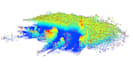

I will process your LiDAR point cloud data and transform it into clear and meaningful forest information. My work focuses on extracting useful insights from raw data, including canopy height models, forest structure metrics, and high-quality spatial maps.
Using GIS and remote sensing tools such as QGIS, CloudCompare, and R, I can clean, analyze, and visualize your LiDAR data to support environmental studies, forest inventory, and geospatial analysis projects.
What you will get:
This gig is ideal for forestry professionals, researchers, and companies working with environmental monitoring, forest inventory, or geospatial data analysis.
If you need custom analysis or have a specific project, feel free to contact me before ordering.
LiDAR, GIS, Remote Sensing, Spatial Data Analyst
Languages
What data do you need from me?
I need your LiDAR point cloud data (LAS/LAZ format) and basic project information such as area of interest and objective.
What will I receive from this gig?
You will receive processed LiDAR outputs such as forest maps, canopy height models, and summary metrics depending on the selected package.
Can you work with large datasets?
Yes, I can handle large LiDAR datasets. Please contact me before ordering for very large or complex projects.
Do you provide analysis or only maps?
Depending on the package, I can provide both maps and analytical insights including forest structure metrics and summaries.
What software do you use?
I use GIS and remote sensing tools such as QGIS, Python, and R for data processing and analysis.


