Browse categories
Explore
Fiverr Pro
English
$
USD


Hello
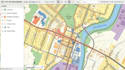
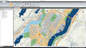
Are you Looking for a professional GIS map, site plan, property map, land development map, subdivision map, plot plan, location map, or interactive mapping solution?
I provide professional mapping services for developers, planners, architects, surveyors, tourism businesses, municipalities, and commercial projects. Using GIS data, satellite imagery, survey information, CAD drawings, and client concepts, I create accurate and visually engaging maps designed for planning, presentations, marketing, and navigation.
Whether you need a property map for a development project, a site plan for a permit application, a GIS map for data visualization, or an interactive map for your website, I can help transform complex information into a professional mapping solution.
Services Include
Why Choose Me
Send your project details and let's create a professional map designed to your needs.
Please inform the freelancer of any preferences or concerns regarding the use of AI tools in the completion and/or delivery of your order.
GIS Mapping, Vector Map Design, Site Plans, Interactive Maps, Cartography
Languages


