Browse categories
Explore
Fiverr Pro
English
$
USD


CONTACT ME BEFORE ORDERING to discuss your project scope and get an accurate quote.
Need a GIS specialist who understands both spatial analysis AND the agriculture/forestry/environmental context behind the data? You're in the right place.
I hold a B.Sc. in Soil Science and have 8 years of hands-on experience in soil survey, GIS, and remote sensing including 1.5 years managing large-scale field mapping operations (~5,000 hectares/month) for a plantation forestry operation. I don't just process spatial data I understand what it's used for on the ground.
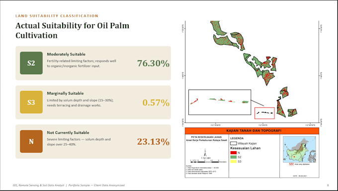
SERVICES INCLUDE: Buffer, overlay, and proximity analysis Land/site suitability mapping (agriculture, forestry, environmental), Boundary delineation and land unit mapping, Vector data digitization and cleanup, DEM-based slope and terrain analysis, Spatial data QA/QC and error correction, Custom thematic maps with proper cartographic layout.
SOFTWARE STACK: ArcGis |QGIS | Google Earth Engine | SRTM/DEM data | OpenStreetMap data | Google AppScript
Let's turn your spatial data into a map that actually supports your decisions. Message me to discuss your project!
GIS Remote Sensing Specialist, Soil Survey Analyst for Agriculture and Forestry
Languages
What GIS software do you use?
I primarily use QGIS (open-source, no licensing limitations for clients) along with Google Earth Engine for satellite-based analysis. I can also work with data exported to/from ArcGIS if needed.
What data do I need to provide?
Ideally, your area of interest (AOI) as coordinates or a shapefile, and any existing data layers relevant to your project (soil data, boundary files, survey points, etc.). If you don't have data ready, I can source public datasets (OpenStreetMap, SRTM DEM, Sentinel-2) depending on the analysis type.
Can you handle agriculture/forestry/plantation-specific projects?
Yes. This is my core specialization. My background is in soil science and I've worked directly on plantation-scale soil mapping and land management operations, so I understand the practical use case behind the map, not just the technical output.
Do you provide the raw GIS files, or just the final map image?
Both. You'll receive the final map layout (PNG/PDF) as well as the underlying shapefile/GIS data, so you can continue working with it if needed.
What if my project doesn't fit these packages?
Please message me before ordering — most spatial analysis projects are scoped individually since area size, data availability, and complexity vary a lot. I'll give you a custom quote.