Browse categories
Explore
Fiverr Pro
English
$
USD


Need a clean, accurate map or real remote-sensing analysis, not just a screenshot? You're in the right place.
I'm a Space Science graduate specializing in GIS and satellite remote sensing. I turn raw satellite imagery (Sentinel, Landsat, MODIS) into decision-ready maps using QGIS, Google Earth Engine and Python.
What I can do:
- Land cover / land use classification
- NDVI, NDWI, NDBI vegetation, water & built-up indices
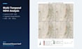
- Change detection (multi-date, before/after)
- Forest, vegetation & crop health monitoring
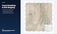
- Flood, drought & disaster mapping
- Study area & thematic maps (publication quality)
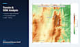
- DEM, slope & terrain analysis
You get:
- High-resolution exports (PNG/PDF/GeoTIFF)
- Editable source files
- Clear methodology so your results are reproducible and defensible
Perfect for researchers, students, thesis projects, agriculture, environment and urban planning.
Not sure what you need? Message me first and I'll tell you exactly what's possible and quote you fairly.
GIS AnalystAI Automation Engineer Customer Service Team Lead
Languages
Do you provide the source/editable files?
Yes. You receive editable source files plus high-resolution exports with every order.
I'm not sure which analysis I need. Can you help?
Absolutely. Message me with your goal and I'll recommend the right approach before you order.
Can you do academic or thesis work with a methodology write-up?
Yes. The Premium package includes a short report documenting the data, methods and results.


